Introduction
Our planet has a vast diversity of climate types. Along the equator, we generally find warm, moist climates that support lush tropical rainforests. If we travel from this location to the poles, we notice that the climate along this trek changes radically. Some of the climates encountered along this journey include tropical savannas with distinct wet and dry seasons; arid, hot subtropical deserts; moist mid-latitude climates with hot to warm summers and mild to cold winters; and bitterly cold, dry polar climates.
So far in this online textbook, we have discovered that the climate of any particular place is a function of several factors. The following discussion will briefly review some of these factors.
Latitude
Latitude influences the reception of insolation on the Earth’s surface. Insolation is a major energy input that generates heat at the Earth’s surface and in the lower atmosphere. On an annual basis, we have found that the potential received solar radiation declines from the equator to the poles. We have also discovered that seasonal variations in solar radiation received increase with latitude (Chapter 4, Earth Geometry and Motions). For instance, high-latitude locations generally go from being in complete darkness in the winter to receiving more solar radiation than the equator does in summer.
Global-Scale Pressure Patterns and Winds
On a global scale, surface pressure patterns and their associated prevailing wind flow are spatially influenced by Hadley, Ferrel, and Polar circulation cells (Chapter 7, Models of Global Circulation). We have also learned that these wind and pressure patterns move with the Sun's seasonal migration. Figure 9.1 provides an idealized model of our planet’s global circulation system and its influence on a location’s climate as a function of latitude. In this graphic, we can see the positions of the major circulation cells in the lower atmosphere and the tropical/subtropical, mid-latitude, and polar air masses during the equinox. This fact is very important in determining the general climatic conditions for locations on Earth. For example, the area 5° of latitude on either side of the equator is primarily influenced by the Intertropical Convergence Zone (ITCZ) year-round, producing warm, wet weather almost every day. A location at 30° N latitude would be influenced by the Subtropical High Pressure Zone and descending air currents, which would produce hot and dry weather all year long. The climate of a place at 60° N would alternate between mild, wet summers and cold, wet winters. When learning about Earth's climatic regions and their classification, as described in the discussion that follows, use this graphic as a guide to understand how global circulation processes affect the climate of any given location throughout the seasons.
Air Masses
As we learned in Chapter 8, large air masses with varying temperature and moisture characteristics form on Earth’s surface (Figure 8.19). Often, these air masses move with atmospheric circulation, influencing the typical weather of a location for periods of days to weeks. For example, the West Coast of continental North America is frequently influenced by maritime tropical and maritime polar air masses that originate in the Pacific Ocean. During the winter months, the central United States often feels the bitter cold of continental arctic air masses that originate in northern Canada.
Storms
Storms such as thunderstorms, mid-latitude cyclones, and hurricanes are extremely important for generating significant amounts of precipitation in many parts of our planet (see Chapter 8). Thunderstorms are the primary source of precipitation in the tropics. In the mid-latitudes, precipitation is mainly generated from thunderstorms that form when temperatures are warm and by frontal lifting associated with mid-latitude cyclones. Hurricanes influence very specific regions on our planet on a somewhat infrequent basis. Despite this fact, a single hurricane can generate enormous quantities of precipitation during its relatively brief existence.
Heat Exchange Between Land and Water
Lakes, seas, and oceans are very effective at supplying additional heat energy to adjacent land-based locations, especially during the nighttime and winter months. This fact is very apparent when you compare the winter climates of locations on the coasts of North America (see Vancouver, Canada, in Figure 9.18) to places with similar latitudes in the interior of the continent (see Winnipeg, Canada, in Figure 9.22). Places surrounded by land experience more extreme daily and annual temperature fluctuations due to the continental effect. Locations near the ocean tend to have milder temperature regimes and often more precipitation. This reality is known as the maritime effect.
Warm ocean currents transport large quantities of heat energy from lower to higher latitudes. For instance, the heat energy carried by the Gulf Stream is responsible for the mild, wet weather experienced in the United Kingdom and on the West Coast of Europe. The influence of the Gulf Stream on this part of the planet is particularly prominent during the winter months. Several cold currents are also found in the oceans. These currents transport cold seawater from higher to lower latitudes. Examples of such currents include the Canary, California, Peru, and Benguela. The presence of cold ocean currents promotes atmospheric stability, reducing precipitation over adjacent land areas (Figure 9.2).
Altitude and Mountain Ranges
In Chapter 5, we discovered that air temperature in the troposphere generally decreases with altitude. This fact can be easily observed when ascending a mountain. On average, the lower atmosphere cools at a lapse rate of about 6.5°C/1000 m (3.5°F/1000 ft). Also, the atmosphere's density declines rapidly with increasing height. This thinning reduces the atmosphere's ability to absorb and radiate longwave radiation, an important energy source for generating sensible heat. As a result of these two factors, locations at high altitude tend to have lower average daily temperatures, greater nighttime cooling, and broader daily temperature ranges than places near sea level, all else equal.
Mountains often act as barriers to prevailing winds and air masses. On the West Coast of North America, mountain belts running north/south prevent the migration of maritime air masses too far inland. As a result, locations east of these mountains tend to have very continental climates, despite their proximity to the Pacific Ocean. Mountain ranges can also influence precipitation patterns (Figure 9.3). On the windward side of the mountains, precipitation is enhanced by orographic uplift and associated adiabatic processes. Rainshadows, regions of reduced precipitation, are common on the leeward face of mountains because of adiabatic compression and warming.
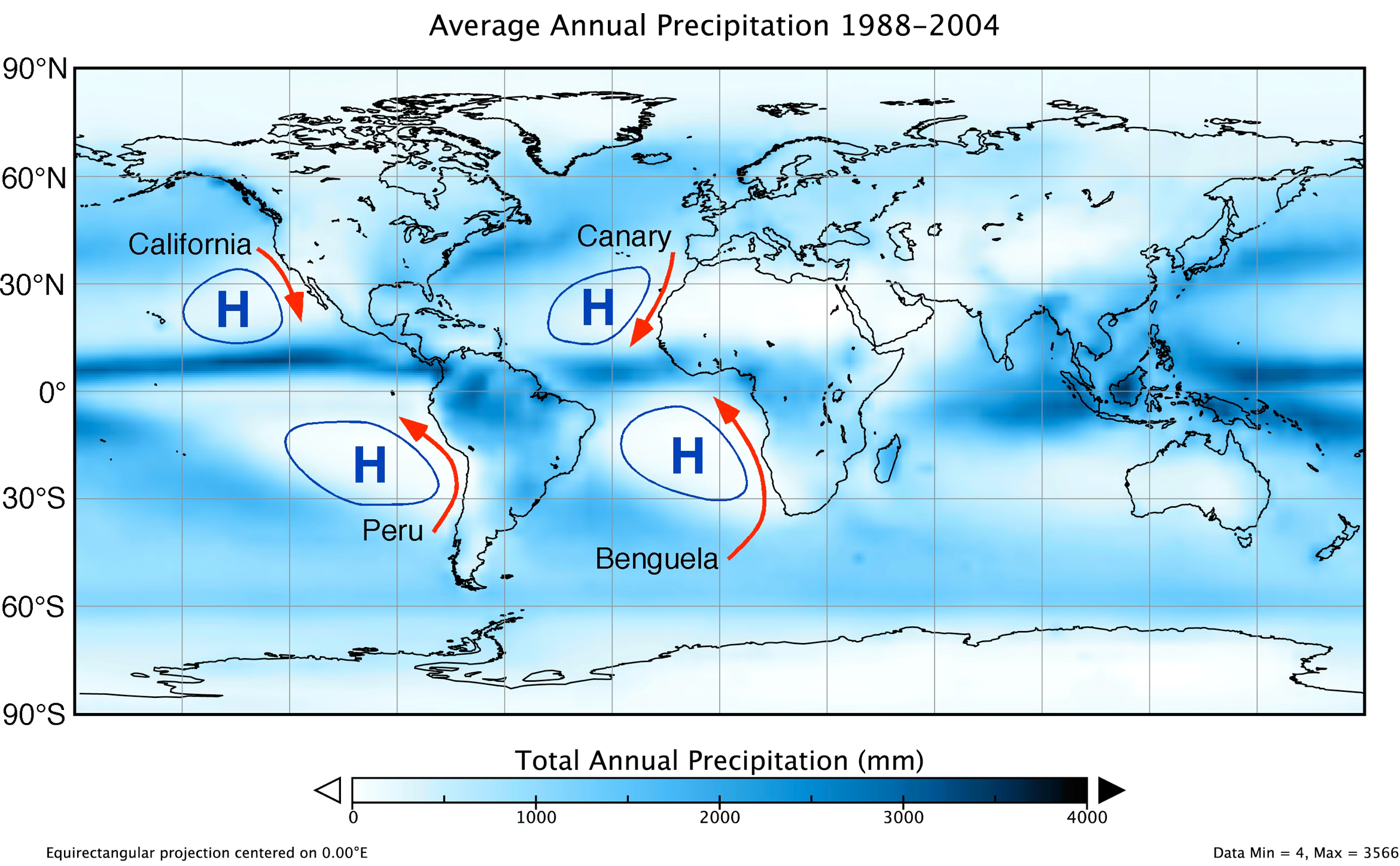
FIGURE 9.2 Association of subtropical highs and cold ocean currents with adjacent areas of low precipitation on the continents. West Coast cold currents help to create arid conditions on adjacent landmasses. The cold temperature of these ocean currents limits the evaporation from these water bodies. One requirement for creating precipitation is having air with high humidity. Modified Image Copyright: Michael Pidwirny, Map Data: Global Precipitation Climatology Project (GPCP).

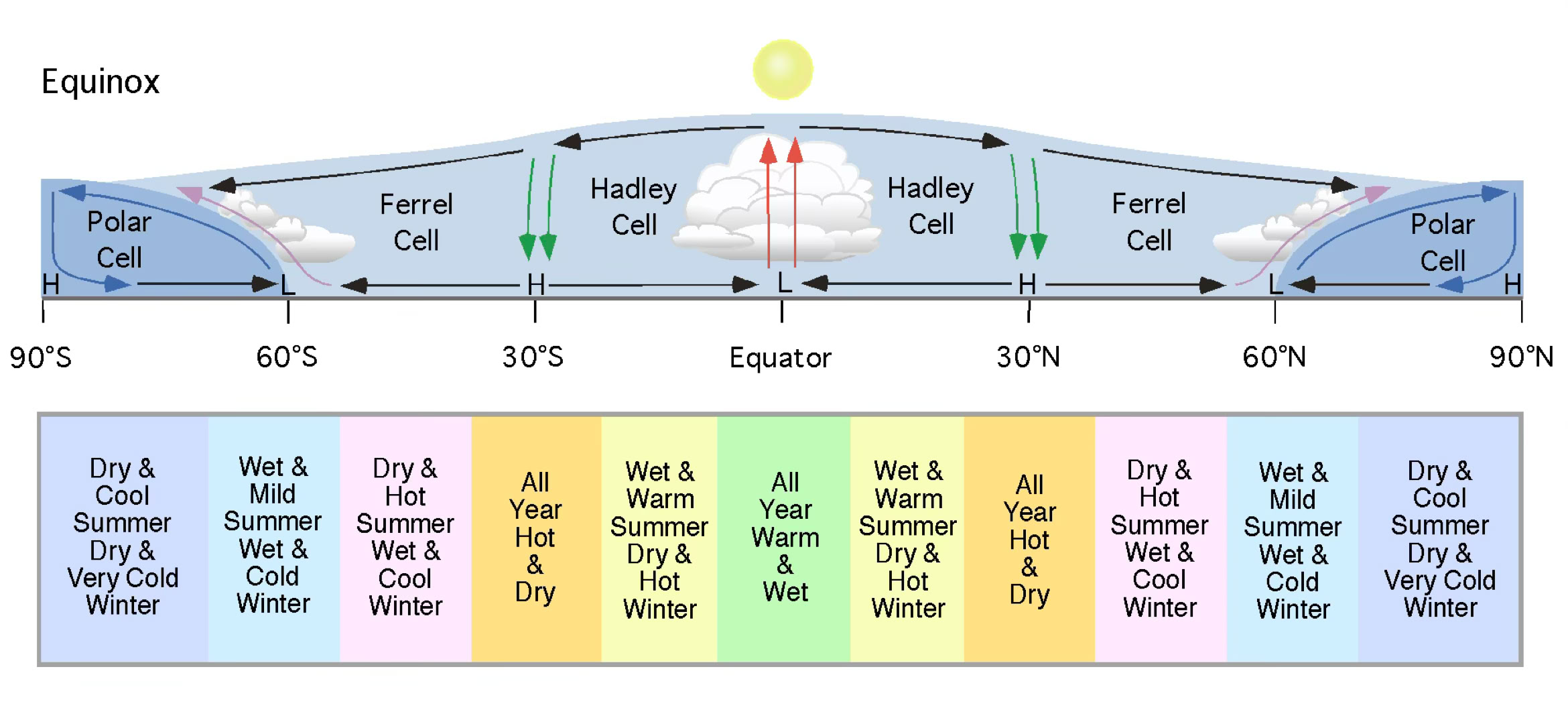
FIGURE 9.1 Vertical cross-section from the South Pole to the North Pole of the Earth’s lower atmosphere showing global circulation cells and areas of rising and descending air circulation. Along the bottom of this image, we can see the various climate zones located along this cross-section. In general, rising air creates precipitation, and sinking air produces dry conditions. Image Copyright: Michael Pidwirny.
FIGURE 9.2 Orographic uplift creates very wet conditions on the windward side of mountains and a dry rainshadow on the leeward side. Image Copyright: Michael Pidwirny.