FIGURE 19.17 The Ekman spiral begins with the wind blowing over the ocean surface (1), producing a force on the topmost layer of seawater in the same direction (2). Also influencing the movement of this water is a force created by the Coriolis effect, acting 90° to the right (90° to the left in the Southern Hemisphere) (4). The action of these two forces produces the realized or actual direction of the surface ocean current (3) in a direction between these two forces. Beneath the surface layer, seawater also moves due to molecular-level contact friction. Layers of seawater molecules are moved by the frictional drag caused by the layer directly above it. However, the force available for this type of movement declines with depth until it stops at about 100 meters (330 feet) below sea level. Image Source: Wikimedia Commons, image by Chabacano. This image is in the Public Domain.
FIGURE 19.16 The five major gyres in the Earth’s oceans. Warm currents associated with each gyre are colored red, cold currents are blue, and neutral temperature currents are white. Image Copyright: Michael Pidwirny.
FIGURE 19.19 Coastal upwelling is common at the subtropical latitudes. This upwelling develops because Ekman transport moves near-surface ocean waters 90° to the right of the prevailing wind flow in the Northern Hemisphere and 90° to the left of the prevailing wind flow in the Southern Hemisphere. Image Source: Wikimedia Commons.
Surface Ocean Currents
An ocean current is defined as a horizontal flow of seawater at the ocean's surface. Wind moving above the ocean surface drives ocean currents. Frictional drag at the interface between the ocean and the wind causes the seawater to move in the direction of the wind. Large ocean currents are a response of the atmosphere and ocean to direct the flow of excess heat energy from the tropics to the poles. In some cases, currents are temporary features and occur only in a small area during specific seasons. Other ocean currents happen essentially all the time, moving large quantities of ocean water over significant distances.
The flow patterns of many of Earth's large ocean currents are controlled by the continental masses found at the sides of the major oceanic basins. When continental borders are located to the left and right of an ocean body, the ocean currents in this type of basin develop a closed circular flow pattern known as agyre (Figure 19.16). The Atlantic and Pacific Oceans have large gyres at about 30° North and South latitudes. The currents in these gyres are driven by the surface wind patterns produced by subtropical high-pressure systems (see Chapter 7, Figure 7.32). Smaller gyres also occur in the North Atlantic and North Pacific Oceans, centered at about 60° North. Currents in these gyres are driven by the winds associated with centers of atmospheric low pressure. Similar ocean current systems do not develop in the Southern Hemisphere because this region lacks the constraining landmasses that drive them in the Northern Hemisphere.
A typical gyre consists of four types of connected currents: two west-east aligned currents found respectively at the top and bottom of the gyre, and two currents oriented north-south. The north-south surface ocean flows are sometimes referred to asboundary currents. This name derives from the fact that these currents are found near the boundary between the ocean and the land surface. Boundary currents also play an important role in redistributing global heat by moving seawater from lower to higher latitudes.
Ekman Spiral and Transport
In Chapter 7, we discovered that the Coriolis effect influences atmospheric circulation by deflecting moving air either to the right (in the Northern Hemisphere) or to the left (in the Southern Hemisphere) of its intended path. The Coriolis effect also alters the movement of ocean currents on our planet. In 1905, physicist V.W. Ekman mathematically predicted how Coriolis would influence the horizontal movement of seawater. Ekman suggested that wind-driven surface currents would travel 45° to the right of the prevailing wind direction in the Northern Hemisphere and 45° to the left in the Southern Hemisphere. Ekman further suggested that the deflection caused by the Coriolis effect would extend to greater ocean depths in successive steps, with each layer being slightly more deflected than the one above it (Figure 19.17). This fact is called theEkman spiral. The Ekman spiral typically extends to a depth of about 100 to 150 meters (330 to 500 feet). Over the entire extent of this distance, the net flow of ocean waters (or Ekman transport) is approximately 90° to the right or left (depending on the hemisphere) of the surface wind direction.
Ekman transport has some other important ramifications that should be mentioned. In subtropical ocean gyres, Ekman transport causes the net flow of seawater toward the gyre's center. As a result, seawater accumulates at the gyre's center, forming a bulge or convergence in the ocean (Figure 19.18). This bulge rises about 1 meter (3 feet) above average sea level at the gyre's center. Gyres driven by polar low-pressure systems operate in the opposite direction. In these systems, Ekman transport moves seawater away from the center of this gyre type, creating surface divergence and a drop in sea surface height. Ekman transport also initiates vertical movements of seawater along coastlines. In the subtropics, the net movement of near-surface seawater along the coast is out to sea. To compensate for this horizontal movement of seawater, a vertical upwelling develops, pulling cold nutrient-rich water up from much greater depths in the ocean (Figure 19.19). Because of the abundance of nutrients, these ocean upwellings support highly productive marine communities. Upwellings of this type are found off the coast of California and Peru.
Surface Currents Associated With Subtropical Gyres
On both sides of the equator, in all three ocean basins, there are two west-flowing ocean currents: the North and South Equatorial Current (Figure 19.20). These currents flow between 3 and 6 kilometers (2 to 4 miles) per day and usually extend 100 to 200 meters (330 to 360 feet) below the ocean surface. The Equatorial Counter Current, which flows towards the east, is a partial return of water carried westward by the North and South Equatorial Currents. In El Niño years, the Equatorial Counter Current intensifies greatly in the Pacific Ocean.
Flowing from the equator to high latitudes are the western boundary currents. These warm water currents have names explicitly associated with their geographical locations: North Atlantic - Gulf Stream; North Pacific – Kuroshio Current; South Atlantic – Brazil Current; South Pacific – East Australia Current; and the Indian Ocean – Agulhas Current. These currents are relatively narrow, fast-moving flows that travel between 40 and 120 kilometers (25 and 75 miles) per day. Western boundary currents are also the deepest ocean surface flows, extending to depths of some 1000 meters (3300 feet).
Flowing from high latitudes to the equator are the eastern boundary currents. These cold water currents also have names associated with their locations: North Atlantic – Canary Current; North Pacific - California Current; South Atlantic – Benguela Current; South Pacific - Peru Current; and the Indian Ocean - West Australia Current. All of these currents are relatively broad and shallow flows that travel at speeds between 3 and 7 kilometers (2 to 4.5 miles) per day.
In the Northern Hemisphere, the east-flowing North Pacific Current and North Atlantic Drift move the waters of the western boundary currents to the starting points of the eastern boundary currents. The South Pacific Current, South Indian Current, and South Atlantic Current function similarly in the Southern Hemisphere. These currents are associated with the Antarctic Circumpolar (also called the West Wind Drift). Because of the absence of landmass at this latitude zone, the Antarctic Circumpolar Current flows in a continuous fashion around Antarctica and provides only a fractional return of water to the three Southern Hemisphere ocean basins.
Surface Currents Associated With the Polar Gyres
Polar gyres occur only in the Atlantic and Pacific basins of the Northern Hemisphere. In the Southern Hemisphere, this similar latitudinal region of the planet is covered by the Antarctic landmass. Polar gyre currents are propelled by the counterclockwise winds associated with the development of permanent low-pressure centers at 60° of latitude over the North Pacific and North Atlantic ocean basins. Note that the bottom west-flowing current of the polar gyres is the same as the topmost flowing current of the subtropical gyres. The ocean flows associated with these gyres include the Alaska Current, Oyashio Current, Norwegian Current, and East Greenland Current (Figure 19.20).
Subsurface Currents
The world's oceans also have significant currents that flow far beneath the sea surface (Figure 19.21). Subsurface currents generally travel at much slower speeds than surface flows. Differences in seawater density propel these subsurface currents. The density of seawater varies across the oceans due to spatial variations in temperature and salinity. Near-surface seawater begins its deep journey into the ocean in the North Atlantic, between Northern Europe and Greenland, and just north of Labrador, Canada. At these locations, high evaporation rates move large amounts of heat energy from the ocean to the atmosphere. This evaporation process also cools the seawater located here and increases its salinity. Consequently, these two processes increase seawater density appreciably, which in turn causes it to sink. This sinking of seawater is also called a downwelling current.
The sinking stops when the downwelling seawater encounters the ocean floor. Unable to continue its descent, the seawater begins to move horizontally southward along the coasts of North and South America until it reaches Antarctica. In Antarctica, the cold, dense seawater then travels eastward, joining another deep-ocean current generated by high evaporation between Antarctica and the southern tip of South America. Slightly into its eastward voyage, the deep cold flow splits into two north-flowing currents. The first north-flowing current occurs in the Indian Ocean off the east coast of Africa. The second north-flowing current develops in the middle of the North Pacific. Both of these currents move from the ocean floor to its surface. These two near-surface currents transport the seawater they carry back to the North Atlantic or to a shallow warm flow that circles around Antarctica. One complete circuit of this subsurface seawater flow is estimated to take about 1000 years.
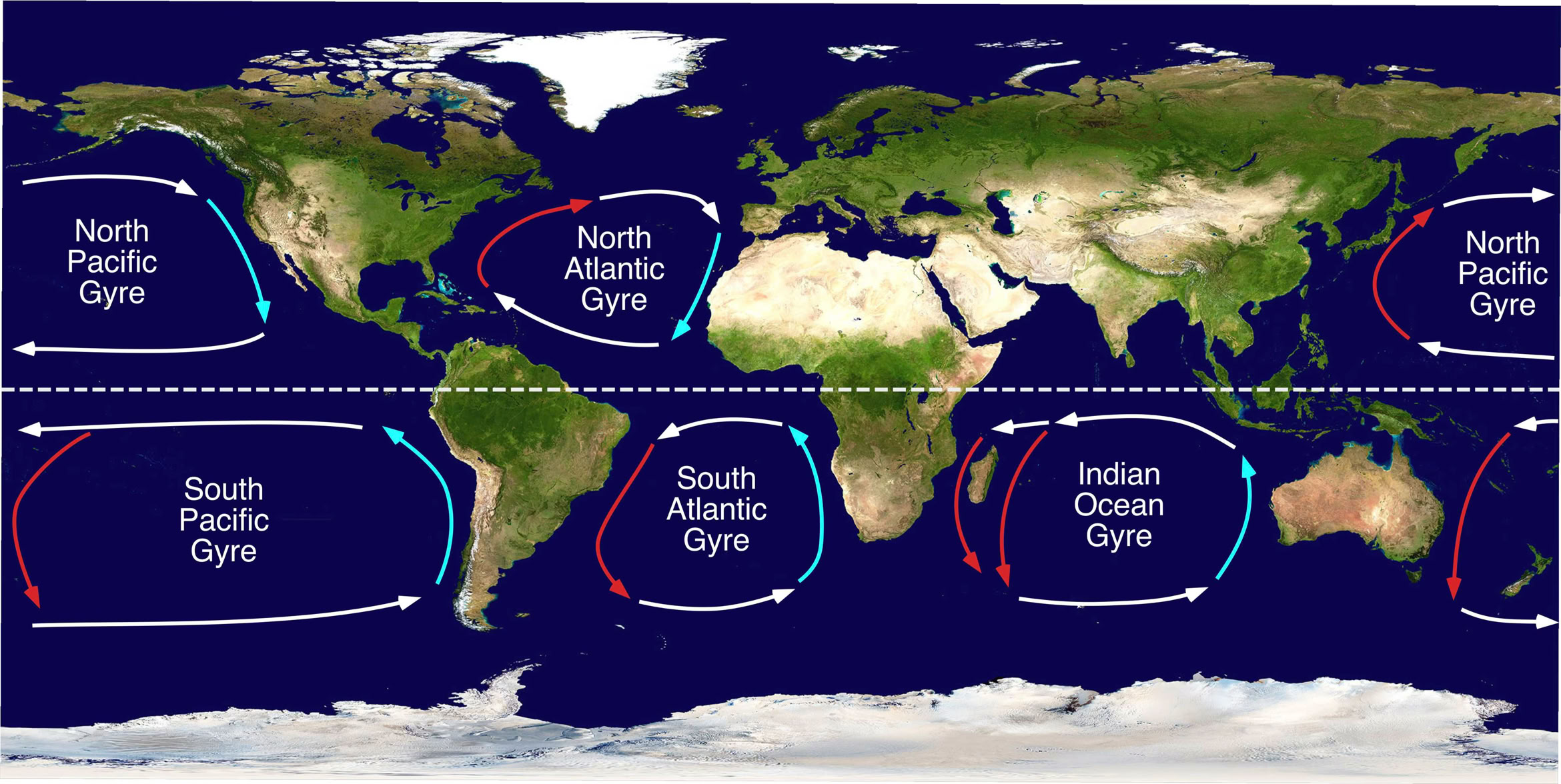
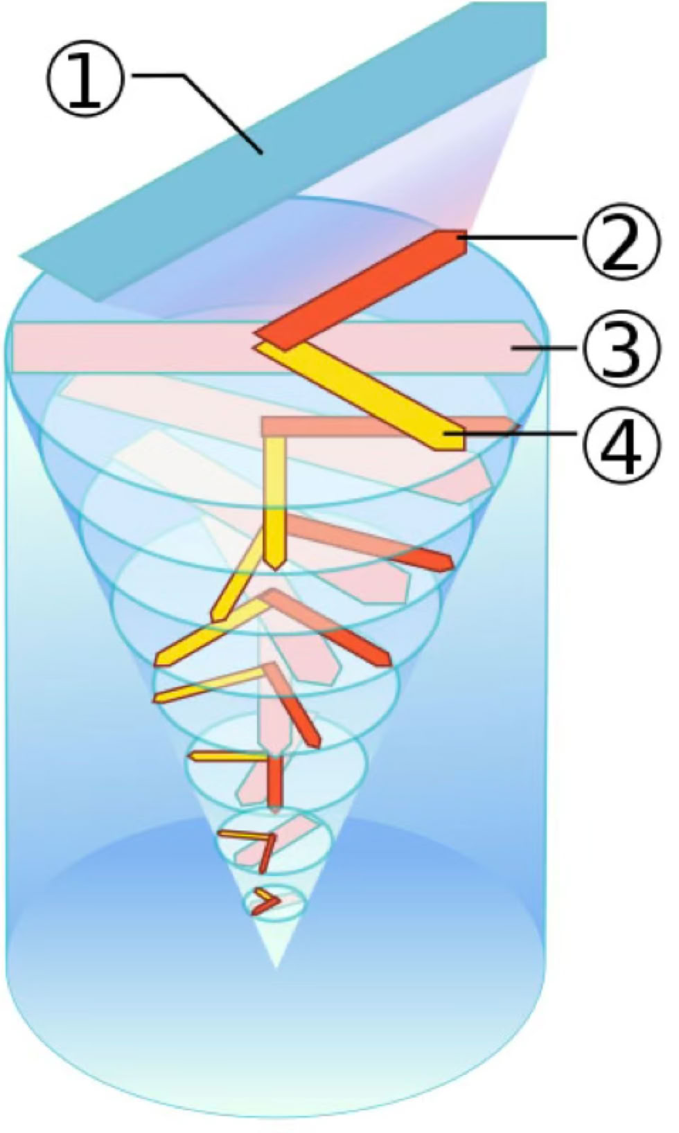

FIGURE 2 The top image shows the ocean currents associated with the dominant high and low pressure centers in the North Atlantic. Ekman transport (yellow arrows) causes seawater to converge and pile up in the middle of the subtropical gyre, driven by the high atmospheric pressure center. Ocean current circulation around the low produces a net flow of near-surface waters away from the center of this gyre. Image Copyright: Michael Pidwirny.

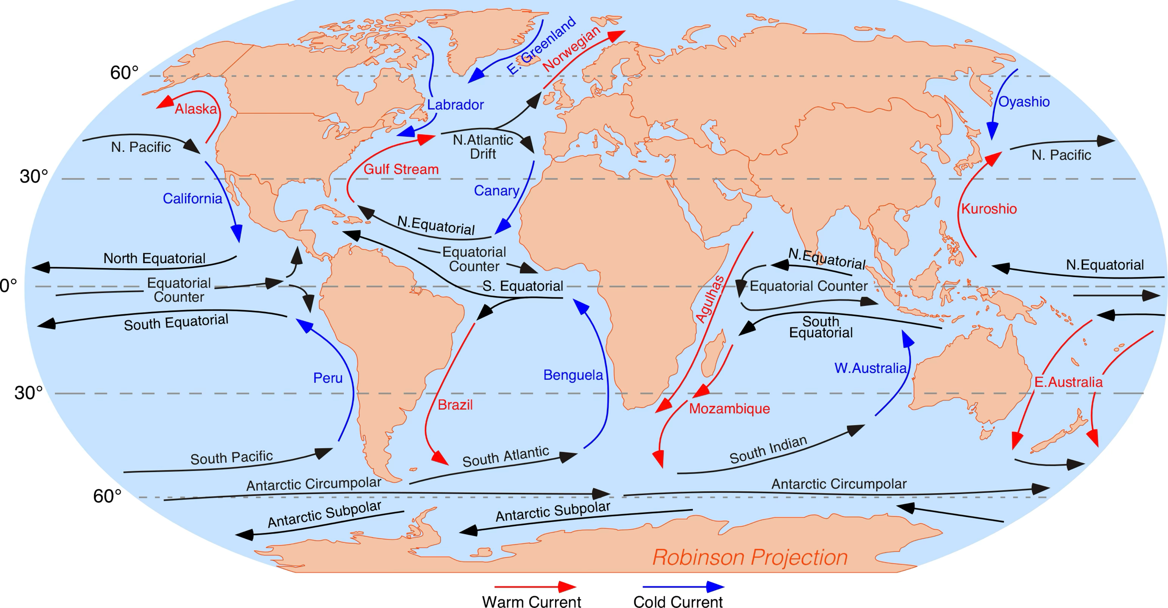

FIGURE 19.20 Major ocean currents of the world. In this illustration, red arrows indicate warm currents, while cold currents are displayed in blue. Image Copyright: Michael Pidwirny.
FIGURE 19.21 The following illustration describes the flow pattern of the major subsurface ocean currents. Near-surface warm currents are drawn in red. Blue depicts the deep cold currents. Note how this system continuously moves water from the surface to deep within the oceans and back to the top of the ocean. Image Source: NASA.